Following on from my last two posts about my PhD fieldwork and research workshops in Kettering, and in St Marys and St Helens in Tasmania, this post documents the fourth and final workshop, held in Tolmans Hill, a suburb of Hobart. Assisting me with the workshop this time was Peter Middleton from the Bushfire Ready Neighbourhoods program at TFS.
Some of the Tolmans Hill community mapping.
We had a small turnout of only six people, but the workshop was still very interesting for both my research and the participants. As with the previous workshops, participants were interested in improving bushfire management, mapping, and my general research (though, as I’ve learnt through this journey, that’s not too remarkable as people wouldn’t attend if they weren’t interested, would they?). Again, they saw a lot of potential in both paper mapping and computer mapping (with similar pros and cons of each as discussed at the other workshops). They generally saw their volunteered geographic information in either paper or digital form as most useful, and most needed, for helping build engagement in bushfire preparation within their community, as opposed to being useful data for emergency response services, for example.
While the mapping activities identified potential safer places, hazards and assets to the community, significantly the activities also revealed to participants how little they knew about other people in their community, how unprepared for and disengaged in bushfire their community probably is, and generally how disconnected their community is. They talked about not even feeling comfortable knocking on their neighbour’s door, which to me was in stark contrast to other communities I visited, such as Kettering where participants were very well-connected and engaged in bushfire to the level that on their maps they were including their various different neighbourhood bushfire management groups. We discussed how important that sense of community might be for improving bushfire preparedness in Tolmans Hill. Referring back to the community map, participants identified things like a location for a playground and potential local coffee shop that may be useful in improving community connections (currently Tolmans Hill is entirely residential and people have to go to other areas for work, school, playgrounds, morning coffee and the newspaper etc). By the end of the workshop the six community members in attendance had exchanged contact details with the aim to start a volunteer working group to begin addressing issues in the community and/or establish a phone tree for bushfire communication. Some decided on going to local Bushcare group events to get more volunteer support from Tolmans Hill and begin removing hazardous weeds in the area, and one even gave his details to join the volunteer fire brigade! Good research findings or otherwise, I felt those were some pretty awesome outcomes of my workshop!
Screenshot of the (incomplete) online community map.
Despite some disappointments, I feel really good to have completed these workshops and my PhD fieldwork! It’s been an encouraging, useful and hugely insightful trip. It’s been super interesting to see how different people think about and relate to the same places in very different ways. I’ve learnt a lot already without even analysing the data I’ve collected, from the organisational and practical aspects of running events through to the nuances of human behaviour, bushfire management and some of the challenges communities and emergency services face. Above all, I am energized by the power of geography and mapping to bring people together, to describe and communicate complex and important information for a range of issues, and to greatly increase our understanding of the world around us.
This fieldwork is funded by the IAWF PhD scholarship and the research is supported by the BNHCRC, Tasmania Fire Service, and the University of Sydney. In particular, I want to thank the people who gave their time and energy to help me in planning for this fieldwork, running the workshops, and spreading the word of the events, including (but I’m sure there are more) Eleanor Bruce, Peter Middleton, Josh Whittaker, Wendy Suthern, Nikki Montenegro, Stephanie Duce, Tegan Hall, Mark Vicol, Lesley King, David Cleaver, Suzette Harrison, RJ McDonald, Val Brown, Annick Ansselin, Nathan Maddock, Lyndsey Wright, Julie Severin, Andrew Johns, Kurt Iveson, Matt Duckham, Verity Coltman and David Gage. I also want to thank all the workshop participants – the research would literally be nothing without you!
Following on from my last post on the community mapping workshop I ran in Kettering, this post describes the next workshops as part of my PhD fieldwork for the topic VGI, community engagement and bushfire preparation. Rather than repeating content from the last post about the research context, and the purpose and description of the workshops, I’ll go straight to discussing how the workshops went and what I observed.
Community members from nearby Scamander began by making comments on existing fire service bushfire planning maps.
At the workshop held in St Marys on Saturday 10 people from the area participated, recruited predominantly through Bushfire Ready Neighbourhoods (BRN) networks, a mail-out to a random sample of 150 households, flyers in local shops and word-of-mouth. Participants were varied, including an emergency management consultant, local council member, farmers, and retirees, for instance, providing a diverse group with useful local knowledge to contribute to the mapping activities. Assisting me with this workshop was David Cleaver from the BRN program at the Tasmania Fire Service, and volunteer assistant from the University of Sydney, RJ McDonald.
Participants were also from varying locations around St Marys and not from the town itself, which made the paper mapping activity a little difficult for some. Their homes and the areas they were most familiar with were not in the frame of the paper maps at the scale I had printed them. This is probably quite typical of many rural and bushfire prone areas with many living in smaller places, often on properties, and travelling to a nearby larger town or community when they need to. This limitation of the paper mapping proved to highlight a benefit of digital mapping for participants where capability exists to navigate the map to different locations and zoom in and out to map information a different scales.
As with the workshop in Kettering, even though some initially found the software a challenge, people generally preferred the computer mapping activity. The paper mapping again was recognised as valuable for its low-tech simplicity for older people and those without internet or computer access and for the connections people make by coming together to work on the maps in person. But apart from the common concerns with online mapping (issues of power outages and computer access; a little worry about privacy and malicious intent) most of the comments on the potential use of web mapping and VGI for bushfire preparation in their community were positive. Rather than leading the web mapping myself like last time, this time I gave a laptop or tablet to the groups to map their information themselves, and, after some hesitation, most then engaged with the activity much more beneficially and began to see even greater potential for mapping in their community. They discussed how portable and up-to-date a web map can be and how useful it may be for others in the community perhaps less engaged in more traditional bushfire preparation activities like forums, such as younger people. They discussed how online mapping would be useful for vulnerable groups such as travellers, people new to the area, and those who speak languages other than English.
Observing the activities and the things participants chose to map, the content tended to focus on response to a fire event, and people didn’t map a lot about their own preparedness. As you can see on the web map screenshot below people mapped services and assets useful to know in a fire event (they also mapped the same things several times – another consideration with crowdsourcing). While this is certainly useful and clearly did still get people engaged in thinking spatially about their bushfire risk and planning, I also see great potential for even more local, more diverse, and more individually-useful information to be mapped. An example might be the locations of people who have tools available to help others clear vegetation and prepare their homes, or sites of cultural significance, or places important to individual families, or identification of vulnerable people in neighbourhoods who might need extra consideration and assistance in preparing for and responding to a fire. And indeed, some participants excitedly discussed at the end of the workshop how they’d like to carry out similar mapping activities in their local areas with their neighbours to better understand bushfire risk and preparation, which was fantastic to hear! Perhaps the real value of mapping and VGI for bushfire preparation lies in the highly local scenario, to create, map, and share geographic information with those at the neighbourhood scale, rather than the broader aggregated community level where the information may become less relevant to specific individuals. As workshop participants said about the paper mapping versus the computer mapping, there is probably value and merit in both.
Community members from nearby Scamander began by making comments on existing fire service bushfire planning maps.A screenshot of the (incomplete) community web map.
On Sunday I set up for a workshop in St Helens with help from Suzette Harrison at the BRN and RJ McDonald. I had been told in advance from those at the local council and those previously trying to undertake community engagement works in St Helens that I may not get a large turnout. However I was still pretty disappointed when not a single person arrived for the workshop. After about an hour waiting we called it a day and packed up. I am running four workshops on this trip, partly to explore how community mapping might work in different types of communities, but also as a safety net in case a workshop doesn’t go too well. So this ‘failure’ is disappointing for me given all the time, money, and effort we put in to the event, but it is not detrimental to the research. I’ve got two successful workshops under my belt already with a great amount of information to work with for my thesis, and I still have one more workshop to come this Saturday (December 5th) in Tolmans Hill, which hopefully will also be a useful event.
But of course I have to stop and question why this particular event failed. When I think about the effort I put in to recruiting participants and advertising the event I can’t see much more I could have done. I contacted people who participated in my research in the past about coming to this event (of which 3 confirmed they would attend). I had flyers up in local businesses and community centres. I contacted many groups in the area initially with a general flyer in the mail and later with a personalised email, including the Lions Club, Rotary, day care centres, community development association, schools, arts groups, and local council, to name a few, with a number of these informing me they would share among their networks. I sent information out to a random sample of 150 households in the area. I had the information shared on various local Facebook pages as well as statewide pages like Tasmania Fire Service and Landcare. I also paid for some advertising on Facebook targetted at the St Helens postcode in the week leading up to the event (apparently my $34 spent got my ad to 400 people’s pages). The workshop was also advertised in council newsletters and on the BRN website. Other ideas I had included spots on local radio, in newspapers, or just random door-knocking. But I’m not sure how much difference that would have made.
I was told this community is particularly hard to reach and my experience is similar to others working in this area. In terms of the research, maybe the interest was low because they’ve done a lot of surveys recently? In terms of bushfire preparedness engagement, maybe they generally feel they are prepared enough? Or (worryingly) perhaps they are complacent about the likelihood of a bushfire event impacting them here? St Helens actually experienced a small bushfire event last year where a number of issues arose that I thought might have made this workshop an interesting one. But even a recent event hasn’t triggered widespread interest in fire management in the area (that I or others have seen). Perhaps the idea of giving up four hours on a weekend was just too unattractive (though, I do provide a free lunch!), or perhaps this community was a little too close in proximity to St Marys (about 35 km away; I actually think they are very different communities in a number of key ways so still think there was justification for choosing both). Even still, while I don’t think word of my workshop reached every one of the few thousand residents, I am pretty certain it reached at least several hundred, and it is a bit baffling that not a single person was interested enough to attend. If that is a reflection of their engagement in bushfire preparation broadly, I must say I’m a bit worried about the potential impacts of a bushfire in St Helens, and hopefully further community engagement activities in the future have more success.
The upside of a failed workshop – more sandwiches for me!
Going forward I need to think a bit more about why St Helens didn’t work and relate that to my last workshop in Tolmans Hill. Is there anything I can do differently this week to ensure a good turnout at my last workshop? As I said earlier, I’ve had a good experience overall on the fieldwork so far, and I’m confident that will continue at the next event. Tolmans Hill is a unique place in that it is so close to a large urban centre (Hobart) yet all the houses are surrounded by bush, and Tolmans Hill itself is an entirely residential suburb (no shops, school etc in the immediate area), so I’m looking forward to seeing how folk there respond to the activities and the potential use of VGI and mapping for bushfire preparation in that area.
Self portrait: waiting for my first workshop attendees to arrive.
I am currently in Tasmania for the last piece of fieldwork for my PhD research into volunteered geographic information (VGI), community engagement and bushfire preparation. VGI refers to the voluntary engagement of private citizens in the creation of geographic information, predominantly through sources such as social media, smartphones and inexpensive online mapping tools. VGI represents a shift in the ways geographic information is created, shared, used and experienced and this has important implications for various applications of geospatial data, including disaster management where the social practice of VGI is changing the traditional top-down structure of emergency management and information creation and dissemination.
In Tasmania I am running research workshops with the aim to explore how mapping and sharing local knowledge about bushfire with others in their community may foster community members’ engagement in disaster preparation. Key questions I am considering include:
1) Is the social practice of contributing and reviewing VGI engaging for bushfire preparation?
2) Is the local knowledge and understanding gained from the mapping valuable to communities?
3) Does the activity of mapping together increase community connectedness?
4) Is the map itself an effective medium for collating and sharing community bushfire information?
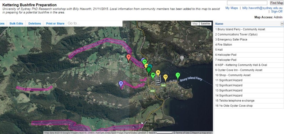
Workshops are being held in four communities, with the first occurring yesterday in Kettering, South West of Hobart. I will post about the other workshops after they happen, but the remainder of this post will focus on the Kettering workshop.
Approximately 20 people turned up to participate in the workshop, sought through engaging local community groups and community fire networks, flyers distributed on noticeboards in Kettering, and sharing through various social media pages, including the Tasmania Fire Service (TFS) page. The workshop format included introductions and a short presentation about the research and the day’s activities, a paper mapping activity followed by lunch, and a digital mapping activity before participants completed a 15-minute questionnaire before the end of the workshop. My PhD supervisor Dr Eleanor Bruce from the University of Sydney and Lesley King from the Bushfire Ready Neighbourhoods program at TFS assisted in running the workshop.
Participants working on their local bushfire preparation map.
The paper mapping activity saw participants in groups of 4-5 marking up paper maps with any information they felt was relevant to bushfire preparation in their community. Groups were each given a satellite image, topographic map, community protection plan (an official fire service document that outlines ‘nearby safer places’ and other fire relevant information for that community), blank paper, plastic overlays, and a suite of textas, stickers and other stationary and told to map whatever and however they wanted using those resources.
I found it really interesting and kind of enjoyable to wander around observing and discussing with the groups the different things they were choosing to map and how different groups thought about the same places in different ways. They mapped a whole range of things, including (but not limited to) community assets like the local pub, regions of high fire danger, potential places of refuge, roads that would be inaccessible to fire trucks, their homes and where their neighbourhood
Paper map completed by one of the groups.
groups were located, what resources were available to help each other prepare, and communication towers. At the end of the exercise groups presented their maps and discussed what they had done with the rest of the participants.
Discussions revealed a number of benefits of the exercise. Some people learned new things about their community in relation to bushfire. Some thought working with others and the
Paper map completed by one of the groups.
discussions between community members the mapping generated was the most valuable aspect. Some downfalls of the activity that were raised included the difficulty in keeping a map up-to-date and sharing it with their broader community and the challenge of getting the information ‘out’ of the paper map so it can be used in other ways, e.g. for the fire service.
The second activity involved collating the information from each group into a combined web map (while it is a bit limited in functionality, we used the Zeemaps platform for its simplicity and accessibility). Initially I demonstrated the platform and then participants talked about what they wanted to add as a collective group. Participants were given a URL to the map and asked to contribute on their smartphones or tablets live in the workshop. Not many people took this up and instead preferred me to ‘drive’ the mapping. Some even seemed a little intimidated by the technology (this could be related to demographics – a large portion of the group were retirees. This probably also reflects the kind of people more interested in fire preparation, as well as those more likely to volunteer their time for a research workshop). This resulted in a slightly awkward lull in the activity with many people not having anything to do while others were adding their information to the web map – something to reconsider for the next workshops. However a useful discussion still ensued where a range of benefits and challenges were discussed. The web map was seen as better for zooming in and mapping finer detail information at ‘micro’ scales (e.g. who has a chainsaw on their street), for sharing the map more widely and easily, for maintaining the relevance of information, for the convenience of contributing when/wherever people liked, for the ability to include more detailed comments and photos with points, and for the potential for more to be done with the data (e.g. GIS analyses). Some issues raised included map ownership, privacy, computer illiteracy of some community members, and the potential ‘messiness’ of all the data points together.
A screenshot of the (incomplete) community web map.
While I haven’t analysed any results yet, a cursory look at the survey responses revealed most people saw a lot of potential and positive applications for community mapping to aid in bushfire preparation. In contrast to my observations during the activity, most people seemed to prefer and rated the computer mapping as more useful. They understood the experimental nature of the activity and recognised its limitations in the workshop setting but saw potential for web maps to be a highly valuable tool and resource in their community along the lines of the benefits described above. Overall people were genuinely interested and positive about the research and the potential outcomes. Considering this was the first time I had attended a research workshop of this nature, let alone designed, organised and ran it, I was really happy with how it went. I even got the catering pretty right! While a part of me is looking forward to my short career in event management being over in a few weeks, I’m interested to see how the next workshops in different communities compare. I’ll post an update when they’re done!
In this short post, the third in a series around my PhD fieldwork in Tasmania, I will briefly provide comment on the end of the trip and the last three communities I visited. In Tasmania I was working in collaboration with the Tasmania Fire Service to visit a number of at-risk communities and survey residents about their bushfire preparation, their use of social media and Volunteered Geographic Information (VGI) technologies, and how they may or may not like to use these technologies for future fire preparations. The aim was to gain insight into the potential role of VGI for fostering community engagement and building individual resilience through connectedness in wildfire preparations, and to build an evidence base for further more detailed work work particular communities in this space. The survey results are still being returned, and my next task is to start collating results. I will endeavour to discuss some of the analyses here in the coming months.
Gladstone – a small rural town in the North East of the state. The population here is small, and there is only one local store. It was difficult to get a good gauge of bushfire preparation here as there really weren’t many people around at the time of day I visited. I could only assume most people farm or work elsewhere. But the fire risk was clear, with the area very dry and bushland close to the perimeter of the township on all sides.
In Hadspen, a community south west of Launceston in northern Tasmania, flammable bushland approaches very closely to the township surrounds. This image was taken at the local sports and recreation grounds, which constitutes a Nearby Safer Place
These last two images both show a view across to Blackstone Heights, a community in broader Launceston characterized by numerous properties at risk positioned on slopes surrounded tightly by bush.
This post continues from my previous regarding my PhD research and associated fieldwork in Tasmania where I’m looking at bushfire preparation and the potential role of volunteered geographic information. As I’m travelling around the state talking with residents in local communities and distributing questionnaires, I’m gaining a lot of insight into many issues around bushfire management and the use of various technologies, and I’ll post about some of these in the future when I’ve begun collating results. In doing this I’ve been lucky to spend time in some beautiful Australian places and the purpose of this post is to share some more pictures from my journey around the state so far.
Swansea – Dolphin Sands is a coastal area in the east coast town of Swansea. Its residents enjoy a quiet living environment surrounded by bush land a stone’s throw away from the beach. But they’re also aware of the persistent bushfire risk in the area. There is a small but active bushfire awareness group in this one-road-in community and custom made signs like the one in this picture installed by the group are a constant reminder of the fire risk in the area.
Coles Bay – A popular tourist destination and this beach at Swanwick shows a number of properties, many of which are holiday homes or part time residents, placed high in the hills surrounded by trees and bush.
Coles Bay – Freycinet National Park is one of Tasmania’s most rugged and most beautiful coastal regions, and Wineglass Bay is a key feature.
Bicheno – Residents of this coastal town will remember fires in the area as recent as January 2013.
St Helens – This is a place with high bushfire risk in the hilly areas that back onto the bush which look over the main town surrounding Georges Bay.
St Helens – Binalong Bay beach is a truly gorgeous spot with clean white sands and paradise blue waters.
Stieglitz – This boat ramp and adjacent cleared area constitutes a Nearby Safer Place (NSP) in the community. NSPs are outlined in the Tasmania Fire ServiceCommunity Protection Plans and are suggested places of last resort that may be ‘safer’ to be during a bushfire event rather than staying at one’s home. Of course the only real ‘safe’ option would be to be prepared and leave the area early well in advance of the fire arriving, but that may not always be the case and thus NSPs are important.
Last July I went back to study at the University of Sydney. I’m studying for a PhD in Geography and working with some truly excellent people. My research is centred around Volunteered Geographic Information (VGI) and natural disaster management. More specifically I’m looking at the potential use of VGI technologies for fostering community engagement in bushfire preparation. This research, now supported by the Bushfire and Natural Hazards Cooperative Research Centre (BNHCRC), has lead me to the beautiful state of Tasmania to work in collaboration with the Tasmania Fire Service (TFS), undertaking fieldwork in high bushfire-risk communities across the state.
Key research objectives include determining the present levels of engagement in bushfire preparation, the present levels of engagement with VGI technologies and social media, and assessing the potential role for VGI to play in building bushfire resilience through community engagement. Through surveys, questionnaires and interviews I aim to gain insight into the following research questions:
What proportion of people currently engages in bushfire preparation?
What proportion of people currently feels empowered about their own bushfire management?
How do people currently engage with their community?
How many people use social media (or other VGI sources) in the community? What tools in particular, and what for?
How many people use or would use social media/VGI in relation to bushfire events, and in what ways?
Is VGI considered a reliable source for bushfire management?
How useful are VGI technologies and social media considered to be for bushfire preparation?
I hope to use this blog to discuss some of the findings of this work in the future, but for now while I am still in Tasmania carrying out the field studies I will just share a few pictures and bits along the way from all the interesting places I’m visiting for this work.
Flying over Tasmania en route to Hobart
Mount Nelson – a suburb in the south of Hobart with many properties on high terrain very close to bushland. The area was significantly impacted by the infamous 1967 fires that devastated southern Tasmania.
Tolmans Hill – a relatively new and small community next to Mount Nelson. This image shows a blackened area where a small fire occurred last week, highlighting the potential danger for people and properties living in areas like this.
Woodbridge – an area again largely impacted by bushfire in the past, Woodbridge to me seemed a highly connected community with many people actively involved in groups to engage fire preparation and local warning strategies, predominantly driven by a few ‘local champions’. This photo was taken looking out over the water from the Peppermint Bay cafe.
Lachlan – a community north of Hobart characterised by properties typically with several acres of land high up in the hills close to bush. The thing that struck me in this area was the number of people living in high risk areas with only one road access. If fires were to block these access roads or damage vital infrastructure, such as wooden bridges, many people could potentially be trapped in place. Considering scenarios like this further highlights to me the importance of preparing for bushfires and having a Bushfire Survival Plan. A good plan may be to leave early, but what if you’re in a situation like mentioned above and there is no way out; if you’re too late to leave, what is your plan B?