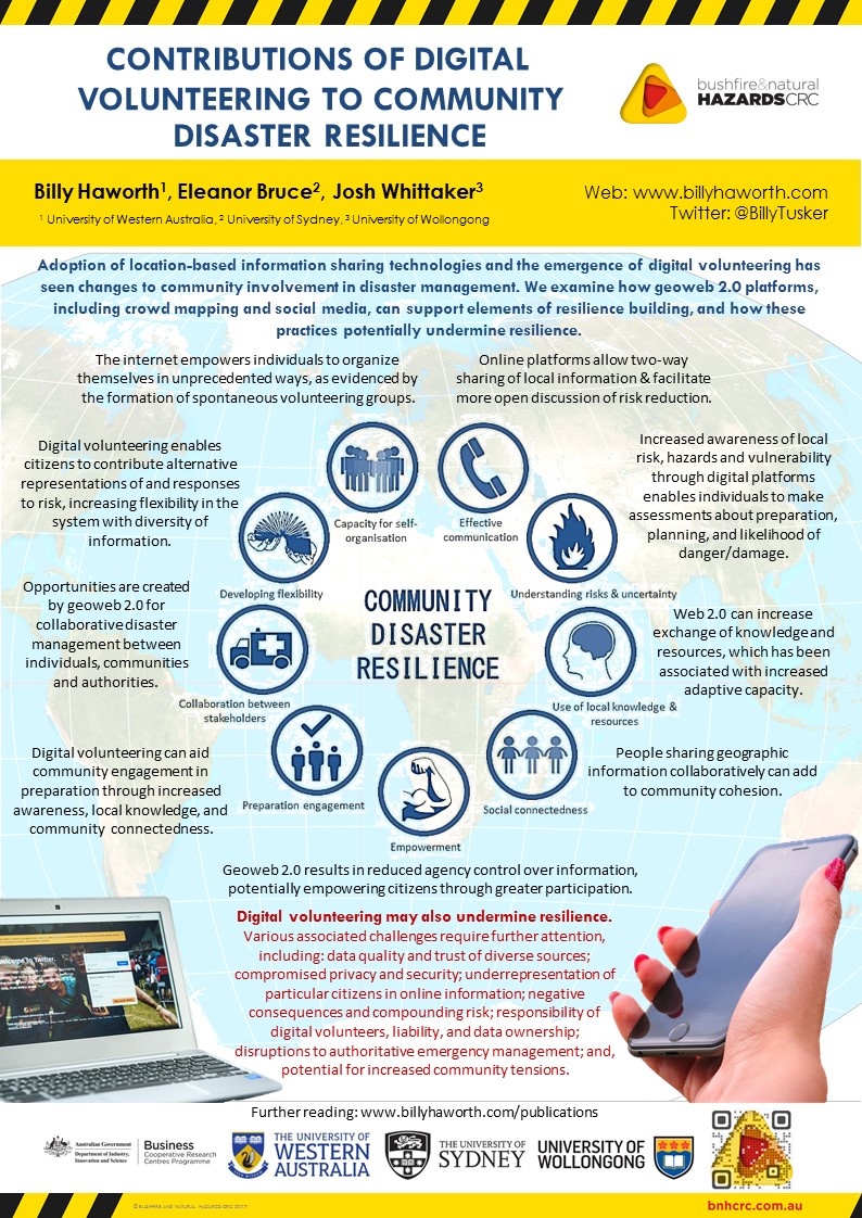
Contributions of digital volunteering to community disaster resilience (BNHCRC Showcase, and AFAC/BNHCRC 2017 conference poster)

Below is a poster I prepared on some aspects of my PhD research into volunteered geographic information and disaster risk reduction. The research in the poster is co-authored by Eleanor Bruce and Josh Whittaker. It was displayed as part of the Bushfire & Natural Hazards Cooperative Research Centre (BNHCRC) Research Showcase event in Adelaide, July 2017, and will also be presented at the AFAC/BNHCRC 2017 annual Fire & Emergency Management conference in Sydney, September 2017.
Download the full high-res version here (7MB): 79._billy_haworth

HAWORTH_bnhcrc-poster-2017

Gratitude: my thesis acknowledgements

There are people I sincerely wanted to thank for their support in various capacities during my PhD. I included some (not all, unfortunately) in the Acknowledgements section of my thesis, but I’m aware only a very tiny number of people in the world will actually read that (basically me plus or minus 1). So, here I paste my acknowledgements, as they appeared in the thesis.

ACKNOWLEDGEMENTS

Version one:

First I wish to acknowledge and pay respect to Aboriginal people past and present as the traditional owners of the land on which I conducted this research, namely the Gadigal people of the Eora Nation, whose ancestral lands the University of Sydney is built upon. I also wish to acknowledge the Tasmanian Aboriginal Community as the traditional and original owners, and continuing custodians of the land on which I conducted my fieldwork. As Aboriginal people continue their struggle for equality and justice in a land that was taken from them, I acknowledge many of the central themes of this thesis, including the value of local knowledge, community, sense of place, land management, and geography have been important for and practised by Aboriginal people on this land for some 60,000 years before I began thinking and writing about them.

I wish to sincerely thank Dr Eleanor Bruce as my PhD supervisor, mentor and friend. More than assisting with the practical, technical and theoretical aspects of my research, which has been instrumental, she encourages me, challenges me, treats me with respect and as an equal, provides opportunities, promotes me and my work, and has fostered enormous growth in me as an early career academic. It is immeasurable how much I have learnt from Eleanor and I am extremely grateful for having worked with her during these formative years.

I also thank my associate supervisors, Dr Joshua Whittaker, Associate Professor Kurt Iveson, and Professor Matt Duckham, whose expertise, guidance and encouragement have been beyond valuable for both the work of this thesis and my professional development. I also acknowledge the broader ‘Out of Uniform’ research team for their support.

I acknowledge the Bushfire & Natural Hazards CRC for providing me with scholarship funding, and I thank them for providing various learning, enriching, networking, and professional and personal development experiences. Lyndsey Wright, Michael Rumsewicz, Nathan Maddock and David Bruce have been especially helpful.

I give sincere thanks to Peter Middleton, the entire Bushfire-Ready Neighbourhoods (BRN) team, and the Tasmania Fire Service for their many forms of support and collaboration in this research. Special mention is given to Lesley King, Suzette Harrison, David Cleaver and Sandra Barber. Working collaboratively with the BRN has shaped my work to be something more meaningful and shaped me to be a more skilled and knowledgeable researcher with a better understanding of the professional and societal context in which my research sits.

There are others not associated with this thesis in an official capacity, but who have contributed significantly nonetheless. Here I wish to thank my officemate (soon to be Dr) Stephanie Duce for her companionship, empathy and encouragement. She is the smartest person I know and I hope she remembers me as her career flourishes. I also thank Dr Caren Cooper, Dr Eloise Biggs and Associate Professor Dale Dominey-Howes for their mentoring and helpful advice.

Perhaps the biggest thank you belongs to the Tasmanian community members and Australian emergency management professionals who participated in my research, either by completing a survey, an interview, or participating in a workshop. If I could name them all without compromising university research ethics, I would, because I am tremendously grateful for their time, patience, and valuable inputs to the research. The worth of local knowledge and the willingness of people to give time to others should never be undervalued.

I thank my friends and especially my housemates for remaining interested and supportive, and for giving me many, many things to enjoy outside of the PhD.

Finally, I give thanks to my family for their love, support and inspiration: Kobe, Latrell, Joe, Tara, Shannon and Jim. I give particular thanks to Dave for his unwavering interest and insightful conversations. And for my Mum, if I am proud of this work and my achievements, that doesn’t compare to how proud I am to be her son. I thank her for allowing me to be everything I am capable of.

To any marginalized individual or group who has ever been underrepresented on a map, or any citizen who has ever had their knowledge undervalued, at any time, in any context, as well as anybody who has never had anything dedicated to them, I dedicate this thesis to you.

Version two:

Cheers, thanks a lot.

Talking partnerships in emergency management (AFAC2016 conference)

(My contribution at 3mins)

Seminar presentation on PhD research: volunteered geographic information and bushfire preparation

Below is a recording of a 20 minute presentation I recently gave on my PhD research as part of the Thinking Space seminar series in the School of Geosciences at the University of Sydney.

Field notes: Community mapping for bushfire preparation in Tolmans Hill, TAS.


Following on from my last two posts about my PhD fieldwork and research workshops in Kettering, and in St Marys and St Helens in Tasmania, this post documents the fourth and final workshop, held in Tolmans Hill, a suburb of Hobart. Assisting me with the workshop this time was Peter Middleton from the Bushfire Ready Neighbourhoods program at TFS.

Presentation1
Some of the Tolmans Hill community mapping.

We had a small turnout of only six people, but the workshop was still very interesting for both my research and the participants. As with the previous workshops, participants were interested in improving bushfire management, mapping, and my general research (though, as I’ve learnt through this journey, that’s not too remarkable as people wouldn’t attend if they weren’t interested, would they?). Again, they saw a lot of potential in both paper mapping and computer mapping (with similar pros and cons of each as discussed at the other workshops). They generally saw their volunteered geographic information in either paper or digital form as most useful, and most needed, for helping build engagement in bushfire preparation within their community, as opposed to being useful data for emergency response services, for example.

While the mapping activities identified potential safer places, hazards and assets to the community, significantly the activities also revealed to participants how little they knew about other people in their community, how unprepared for and disengaged in bushfire their community probably is, and generally how disconnected their community is. They talked about not even feeling comfortable knocking on their neighbour’s door, which to me was in stark contrast to other communities I visited, such as Kettering where participants were very well-connected and engaged in bushfire to the level that on their maps they were including their various different neighbourhood bushfire management groups. We discussed how important that sense of community might be for improving bushfire preparedness in Tolmans Hill. Referring back to the community map, participants identified things like a location for a playground and potential local coffee shop that may be useful in improving community connections (currently Tolmans Hill is entirely residential and people have to go to other areas for work, school, playgrounds, morning coffee and the newspaper etc). By the end of the workshop the six community members in attendance had exchanged contact details with the aim to start a volunteer working group to begin addressing issues in the community and/or establish a phone tree for bushfire communication. Some decided on going to local Bushcare group events to get more volunteer support from Tolmans Hill and begin removing hazardous weeds in the area, and one even gave his details to join the volunteer fire brigade! Good research findings or otherwise, I felt those were some pretty awesome outcomes of my workshop!

zeemap_TolmansHill.jpg
Screenshot of the (incomplete) online community map.

Despite some disappointments, I feel really good to have completed these workshops and my PhD fieldwork! It’s been an encouraging, useful and hugely insightful trip. It’s been super interesting to see how different people think about and relate to the same places in very different ways. I’ve learnt a lot already without even analysing the data I’ve collected, from the organisational and practical aspects of running events through to the nuances of human behaviour, bushfire management and some of the challenges communities and emergency services face. Above all, I am energized by the power of geography and mapping to bring people together, to describe and communicate complex and important information for a range of issues, and to greatly increase our understanding of the world around us.

This fieldwork is funded by the IAWF PhD scholarship and the research is supported by the BNHCRC, Tasmania Fire Service, and the University of Sydney. In particular, I want to thank the people who gave their time and energy to help me in planning for this fieldwork, running the workshops, and spreading the word of the events, including (but I’m sure there are more) Eleanor Bruce, Peter Middleton, Josh Whittaker, Wendy Suthern, Nikki Montenegro, Stephanie Duce, Tegan Hall, Mark Vicol, Lesley King, David Cleaver, Suzette Harrison, RJ McDonald, Val Brown, Annick Ansselin, Nathan Maddock, Lyndsey Wright, Julie Severin, Andrew Johns, Kurt Iveson, Matt Duckham, Verity Coltman and David Gage. I also want to thank all the workshop participants – the research would literally be nothing without you!

Field notes: Community mapping for bushfire preparation in St Marys and St Helens, TAS.

Following on from my last post on the community mapping workshop I ran in Kettering, this post describes the next workshops as part of my PhD fieldwork for the topic VGI, community engagement and bushfire preparation. Rather than repeating content from the last post about the research context, and the purpose and description of the workshops, I’ll go straight to discussing how the workshops went and what I observed.

St Marys (2)
Community members from nearby Scamander began by making comments on existing fire service bushfire planning maps.

At the workshop held in St Marys on Saturday 10 people from the area participated, recruited predominantly through Bushfire Ready Neighbourhoods (BRN) networks, a mail-out to a random sample of 150 households, flyers in local shops and word-of-mouth. Participants were varied, including an emergency management consultant, local council member, farmers, and retirees, for instance, providing a diverse group with useful local knowledge to contribute to the mapping activities. Assisting me with this workshop was David Cleaver from the BRN program at the Tasmania Fire Service, and volunteer assistant from the University of Sydney, RJ McDonald.

Participants were also from varying locations around St Marys and not from the town itself, which made the paper mapping activity a little difficult for some. Their homes and the areas they were most familiar with were not in the frame of the paper maps at the scale I had printed them. This is probably quite typical of many rural and bushfire prone areas with many living in smaller places, often on properties, and travelling to a nearby larger town or community when they need to. This limitation of the paper mapping proved to highlight a benefit of digital mapping for participants where capability exists to navigate the map to different locations and zoom in and out to map information a different scales.

As with the workshop in Kettering, even though some initially found the software a challenge, people generally preferred the computer mapping activity. The paper mapping again was recognised as valuable for its low-tech simplicity for older people and those without internet or computer access and for the connections people make by coming together to work on the maps in person. But apart from the common concerns with online mapping (issues of power outages and computer access; a little worry about privacy and malicious intent) most of the comments on the potential use of web mapping and VGI for bushfire preparation in their community were positive. Rather than leading the web mapping myself like last time, this time I gave a laptop or tablet to the groups to map their information themselves, and, after some hesitation, most then engaged with the activity much more beneficially and began to see even greater potential for mapping in their community. They discussed how portable and up-to-date a web map can be and how useful it may be for others in the community perhaps less engaged in more traditional bushfire preparation activities like forums, such as younger people. They discussed how online mapping would be useful for vulnerable groups such as travellers, people new to the area, and those who speak languages other than English.

Observing the activities and the things participants chose to map, the content tended to focus on response to a fire event, and people didn’t map a lot about their own preparedness. As you can see on the web map screenshot below people mapped services and assets useful to know in a fire event (they also mapped the same things several times – another consideration with crowdsourcing). While this is certainly useful and clearly did still get people engaged in thinking spatially about their bushfire risk and planning, I also see great potential for even more local, more diverse, and more individually-useful information to be mapped. An example might be the locations of people who have tools available to help others clear vegetation and prepare their homes, or sites of cultural significance, or places important to individual families, or identification of vulnerable people in neighbourhoods who might need extra consideration and assistance in preparing for and responding to a fire. And indeed, some participants excitedly discussed at the end of the workshop how they’d like to carry out similar mapping activities in their local areas with their neighbours to better understand bushfire risk and preparation, which was fantastic to hear! Perhaps the real value of mapping and VGI for bushfire preparation lies in the highly local scenario, to create, map, and share geographic information with those at the neighbourhood scale, rather than the broader aggregated community level where the information may become less relevant to specific individuals. As workshop participants said about the paper mapping versus the computer mapping, there is probably value and merit in both.

St Marys (4)
Community members from nearby Scamander began by making comments on existing fire service bushfire planning maps.
zeemap_stmarys
A screenshot of the (incomplete) community web map.

On Sunday I set up for a workshop in St Helens with help from Suzette Harrison at the BRN and RJ McDonald. I had been told in advance from those at the local council and those previously trying to undertake community engagement works in St Helens that I may not get a large turnout. However I was still pretty disappointed when not a single person arrived for the workshop. After about an hour waiting we called it a day and packed up. I am running four workshops on this trip, partly to explore how community mapping might work in different types of communities, but also as a safety net in case a workshop doesn’t go too well. So this ‘failure’ is disappointing for me given all the time, money, and effort we put in to the event, but it is not detrimental to the research. I’ve got two successful workshops under my belt already with a great amount of information to work with for my thesis, and I still have one more workshop to come this Saturday (December 5th) in Tolmans Hill, which hopefully will also be a useful event.

But of course I have to stop and question why this particular event failed. When I think about the effort I put in to recruiting participants and advertising the event I can’t see much more I could have done. I contacted people who participated in my research in the past about coming to this event (of which 3 confirmed they would attend). I had flyers up in local businesses and community centres. I contacted many groups in the area initially with a general flyer in the mail and later with a personalised email, including the Lions Club, Rotary, day care centres, community development association, schools, arts groups, and local council, to name a few, with a number of these informing me they would share among their networks. I sent information out to a random sample of 150 households in the area. I had the information shared on various local Facebook pages as well as statewide pages like Tasmania Fire Service and Landcare. I also paid for some advertising on Facebook targetted at the St Helens postcode in the week leading up to the event (apparently my $34 spent got my ad to 400 people’s pages). The workshop was also advertised in council newsletters and on the BRN website. Other ideas I had included spots on local radio, in newspapers, or just random door-knocking. But I’m not sure how much difference that would have made.

I was told this community is particularly hard to reach and my experience is similar to others working in this area. In terms of the research, maybe the interest was low because they’ve done a lot of surveys recently? In terms of bushfire preparedness engagement, maybe they generally feel they are prepared enough? Or (worryingly) perhaps they are complacent about the likelihood of a bushfire event impacting them here? St Helens actually experienced a small bushfire event last year where a number of issues arose that I thought might have made this workshop an interesting one. But even a recent event hasn’t triggered widespread interest in fire management in the area (that I or others have seen). Perhaps the idea of giving up four hours on a weekend was just too unattractive (though, I do provide a free lunch!), or perhaps this community was a little too close in proximity to St Marys (about 35 km away; I actually think they are very different communities in a number of key ways so still think there was justification for choosing both). Even still, while I don’t think word of my workshop reached every one of the few thousand residents, I am pretty certain it reached at least several hundred, and it is a bit baffling that not a single person was interested enough to attend. If that is a reflection of their engagement in bushfire preparation broadly, I must say I’m a bit worried about the potential impacts of a bushfire in St Helens, and hopefully further community engagement activities in the future have more success.

12312349_10156501401060019_2104033360_n
The upside of a failed workshop – more sandwiches for me!

Going forward I need to think a bit more about why St Helens didn’t work and relate that to my last workshop in Tolmans Hill. Is there anything I can do differently this week to ensure a good turnout at my last workshop? As I said earlier, I’ve had a good experience overall on the fieldwork so far, and I’m confident that will continue at the next event. Tolmans Hill is a unique place in that it is so close to a large urban centre (Hobart) yet all the houses are surrounded by bush, and Tolmans Hill itself is an entirely residential suburb (no shops, school etc in the immediate area), so I’m looking forward to seeing how folk there respond to the activities and the potential use of VGI and mapping for bushfire preparation in that area.

This fieldwork is funded by the IAWF PhD scholarship and the research is supported by the BNHCRC, Tasmania Fire Service, and the University of Sydney.

Field notes: Community mapping for bushfire preparation in Kettering, TAS

12248170_10156475332675019_3150498197056109497_o
Self portrait: waiting for my first workshop attendees to arrive.

I am currently in Tasmania for the last piece of fieldwork for my PhD research into volunteered geographic information (VGI), community engagement and bushfire preparation. VGI refers to the  voluntary engagement of private citizens in the creation of geographic information, predominantly through sources such as social media, smartphones and inexpensive online mapping tools. VGI represents a shift in the ways geographic information is created, shared, used and experienced and this has important implications for various applications of geospatial data, including disaster management where the social practice of VGI is changing the traditional top-down structure of emergency management and information creation and dissemination.

In Tasmania I am running research workshops with the aim to explore how mapping and sharing local knowledge about bushfire with others in their community may foster community members’ engagement in disaster preparation. Key questions I am considering include:

1) Is the social practice of contributing and reviewing VGI engaging for bushfire preparation?
2) Is the local knowledge and understanding gained from the mapping valuable to communities?
3) Does the activity of mapping together increase community connectedness?
4) Is the map itself an effective medium for collating and sharing community bushfire information?

Workshops are being held in four communities, with the first occurring yesterday in Kettering, South West of Hobart. I will post about the other workshops after they happen, but the remainder of this post will focus on the Kettering workshop.

Approximately 20 people turned up to participate in the workshop, sought through engaging local community groups and community fire networks, flyers distributed on noticeboards in Kettering, and sharing through various social media pages, including the Tasmania Fire Service (TFS) page. The workshop format included introductions and a short presentation about the research and the day’s activities, a paper mapping activity followed by lunch, and a digital mapping activity before participants completed a 15-minute questionnaire before the end of the workshop. My PhD supervisor Dr Eleanor Bruce from the University of Sydney and Lesley King from the Bushfire Ready Neighbourhoods program at TFS assisted in running the workshop.

Kettering (2)
Participants working on their local bushfire preparation map.

The paper mapping activity saw participants in groups of 4-5 marking up paper maps with any information they felt was relevant to bushfire preparation in their  community. Groups were each given a satellite image, topographic map, community protection plan (an official fire service document that outlines ‘nearby safer places’ and other fire relevant information for that community), blank paper, plastic overlays, and a suite of textas, stickers and other stationary and told to map whatever and however they wanted using those resources.

I found it really interesting and kind of enjoyable to wander around observing and discussing with the groups the different things they were choosing to map and how different groups thought about the same places in different ways. They mapped a whole range of things, including (but not limited to) community assets like the local pub, regions of high fire danger, potential places of refuge, roads that would be inaccessible to fire trucks, their homes and where their neighbourhood

Kettering (10)
Paper map completed by one of the groups.

groups were located, what resources were available to help each other prepare, and communication towers. At the end of the exercise groups presented their maps and discussed what they had done with the rest of the participants.


Discussions revealed a number of benefits of the exercise. Some people learned new things about their community in relation to bushfire. Some thought working with others and the

Kettering (13)
Paper map completed by one of the groups.

discussions between community members the mapping generated was the most valuable aspect. Some downfalls of the activity that were raised included the difficulty in keeping a map up-to-date and sharing it with their broader community and the challenge of getting the information ‘out’ of the paper map so it can be used in other ways, e.g. for the fire service.

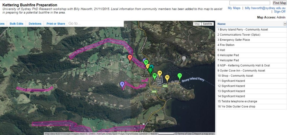
The second activity involved collating the information from each group into a combined web map (while it is a bit limited in functionality, we used the Zeemaps platform for its simplicity and accessibility). Initially I demonstrated the platform and then participants talked about what they wanted to add as a collective group. Participants were given a URL to the map and asked to contribute on their smartphones or tablets live in the workshop. Not many people took this up and instead preferred me to ‘drive’ the mapping. Some even seemed a little intimidated by the technology (this could be related to demographics – a large portion of the group were retirees. This probably also reflects the kind of people more interested in fire preparation, as well as those more likely to volunteer their time for a research workshop). This resulted in a slightly awkward lull in the activity with many people not having anything to do while others were adding their information to the web map – something to reconsider for the next workshops. However a useful discussion still ensued where a range of benefits and challenges were discussed. The web map was seen as better for zooming in and mapping finer detail information at ‘micro’ scales (e.g. who has a chainsaw on their street), for sharing the map more widely and easily, for maintaining the relevance of information, for the convenience of contributing when/wherever people liked, for the ability to include more detailed comments and photos with points, and for the potential for more to be done with the data (e.g. GIS analyses). Some issues raised included map ownership, privacy, computer illiteracy of some community members, and the potential ‘messiness’ of all the data points together.

workshop_zeemap
A screenshot of the (incomplete) community web map.

While I haven’t analysed any results yet, a cursory look at the survey responses revealed most people saw a lot of potential and positive applications for community mapping to aid in bushfire preparation. In contrast to my observations during the activity, most people seemed to prefer and rated the computer mapping as more useful. They understood the experimental nature of the activity and recognised its limitations in the workshop setting but saw potential for web maps to be a highly valuable tool and resource in their community along the lines of the benefits described above. Overall people were genuinely interested and positive about the research and the potential outcomes. Considering this was the first time I had attended a research workshop of this nature, let alone designed, organised and ran it, I was really happy with how it went. I even got the catering pretty right! While a part of me is looking forward to my short career in event management being over in a few weeks, I’m interested to see how the next workshops in different communities compare. I’ll post an update when they’re done!

This fieldwork is funded by the IAWF PhD scholarship and the research is supported by the BNHCRC, Tasmania Fire Service, and the University of Sydney.

Connecting, informing, and building relationships: notes from the 2015 BNHCRC sustainable volunteering workshop

This week the Bushfire & Natural Hazards Cooperative Research Centre (BNHCRC) Sustainable Volunteering cluster held a workshop to report on research progress, help develop research agendas for 2016, and identify end user utilisation needs. The workshop was hosted by Blythe McLennan, John Handmer and Josh Whittaker at the RMIT Centre for Risk and Community Safety in Melbourne and was attended by researchers, students, and emergency organisation representatives, or end users, from around the country involved in two research projects:

Each project gave a number of presentations which were then discussed. End users offered their thoughts, particularly in breakout sessions centred on improving research utilisation, and a guest presenter, Professor Mary Comerio from the University of California, Berkeley, gave a keynote presentation on resilience, recovery and community renewal.

Presenting my PhD research

For me personally the event was beneficial in a number of ways, including:

  • I was able to present my PhD work to a varied and diverse audience of both people with research backgrounds and those in industry and professional roles (the StoryMap I used for my presentation is here: http://tinyurl.com/nzxrju4). My research investigates the social practice of citizens creating and sharing geographic information in disaster management and the potential use of enabling technologies, such as crowdsourced mapping, social media and smartphones, for increasing community engagement in bushfire preparation. These practices are quite dramatically impacting professional systems and traditional authoritative emergency management. So, to have that breadth of expertise in the field listening to and commenting on my findings was a unique and valuable experience.
  • Being located in different cities, it was an excellent opportunity to catch up on how the broader research my own work is connected to is progressing.
  • I was able to foster existing connections with other researchers in my project (Out of uniform) and its end users, engage with complementary research, and also make new ties important for my current research and my future career.
  • I gained useful insight into the collaborative research process between academia and industry.
  • I gained insight into the challenges of research communication and utilisation, particularly in attempting to align research goals and outcomes with agency needs whilst navigating often-rigid organisation structures and processes. The sometimes-competing nature of these two different systems and ways of operating with different needs and different values at times felt a little akin to my own research, which considers how to align mostly-unstructured citizen information-sharing practices with highly structured formal systems of information control and dissemination in authoritative emergency management. In both cases I think balance is important to gain the most beneficial and optimised outcomes for all parties. A balance of needs and methods to meet those needs, but also a balance of expectations.
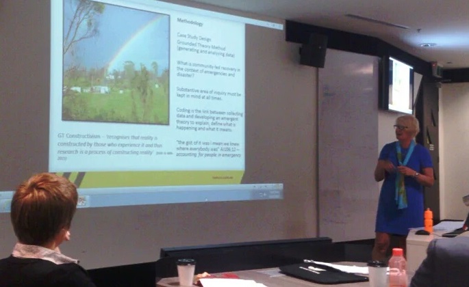
Fiona Jennings presenting her PhD research

One minor concern I had during the workshop was that perhaps some other people important in the research needed to be there for these discussions. While it was fantastic to have the interaction of researchers and agencies, I thought, who was missing? Given the out of uniform project in particular is centered on people volunteering and participating in disaster management outside of formal or traditional settings (e.g. emergent community groups, spontaneous volunteers, online activities), I felt more people from community engagement organisations and roles, as well as representatives of these non-traditional volunteering groups would have been extremely valuable contributors in the workshop. PhD student at RMIT Fiona Jennings’ research, for example, is exploring community-led bushfire recovery with really valuable insights even in its early stages. While Fiona’s research clearly has important lessons for emergency agencies, I felt like the real ‘end users’ of her research might in fact be community organisations and community members undertaking disaster recovery. Yet, representatives of those groups unfortunately weren’t as present at the event and hence not included in the discussions.

Overall I thought it was a really useful event and I’m grateful for the opportunity to be involved. My impression is it is quite rare in academic research to have such a close relationship with industry like the BNHCRC provides. While the end users may benefit from the researcher’s findings, we also benefit enormously from having their input throughout the research journey. I’m unlikely the first person to say it, but perhaps ‘end user’ is the wrong term. This workshop alone highlights the important role the agency representatives play in contributing to the research development, progression and utilisation as partners, not simply end users of the outputs, and I hope they remain active and excited about their involvement in the research. I look forward to the next opportunity for us to share more ideas in the future.

AAG Annual Meeting, Chicago 2015: Reflections

Recently I attended the Association of American Geographers 2015 annual meeting in Chicago, IL, along with several thousand other “geographers” from around the world. Being the largest academic geography conference in the world, even navigating the program was a little overwhelming with over 6000 items, let alone the event itself. But that volume of presenters also means a lot of interesting research, and this post attempts to document some of that. I won’t be listing everything I experienced, but rather just summarising some of my highlights from the week.

Tuesday April 21

First up on the first day was my own presentation, as part of the session Advances in Geospatial Emergency Management, organised by Professor Matt Duckham at the University of Melbourne (one of my associate supervisors) and Professor Mark Horner at Florida State University.

My paper, Engaging Communities in Disaster Risk Reduction through Volunteered Geographic Information: A case study of bushfires (wildfires) in Tasmania, Australia, was really a broad overview of my PhD research. The paper described how VGI represents shifts in the way geospatial information is produced, shared, used, and experienced, resulting in changes to social practices, top-down approaches to mapping and information dissemination, and the broader disciplines of geography and GIScience, with significant implications for various applications, including emergency management. This research considers the potential of VGI to transform disaster management by thinking about VGI as a social practice and not simply a type of information.  This leads to thinking about change in cultural practices in emergency management away from authoritative top-down systems. Giving power to citizens through VGI aids in sustaining community involvement in disaster management, changing behaviours, and ultimately increasing disaster resilience. The paper called for a need to critically assess the role of VGI in the important disaster management phase of preparedness by emphasizing the majority of research in this field to date has only considered disaster response. The research presented focused on VGI for increasing bushfire preparation engagement in Tasmania, outlining key research methods, such as community surveys, interviews with emergency management professionals, and community participatory mapping workshops, along with some preliminary findings.
In the same session I found the impromptu presentation by Matt Duckham on some of the work from his RISER (Resilient Information Systems for Emergency Response) project very interesting. Matt argued that in a time of increased looking to social media for crowdsourced information in disaster management, there are other sources of information from that crowd that are both highly useful and sometimes perhaps more reliable. He noted that in the event of bushfire actually finding the exact location of the fire can be a real challenge, and demonstrated a model that predicted fire locations using crowdsourced data in the form of calls to the emergency services with impressive accuracy. There is a special journal issue in ‘Computers, Environment & Urban Systems’ calling for papers that accompanies this session. More details and submission information can be found here.

Later in the day the panel session, CyberGIS symposium: frontiers of Big Data and urban informatics, chaired by Vonu Thakuriah of the Urban Big Data Centre, raised some interesting questions around the benefits and challenges of big data, researching with big data and theory versus data driven models, privacy, the aggregation of data and industry ownership, and democratization and the notion of an open data economy.

Wednesday April 22

In the morning session Analysing resilience through disaster response, risk perception and risk communication, research in Portugal showed emergency authorities to be under-prepared for ‘lower risk’ emergencies, such as hail and lightning strikes (as opposed to floods, earthquakes etc), with significant negative implications for affected communities. PhD research modelling the coverage and response times of fire services in a province of Ghana was presented, using GIS to improve the efficiency and effectiveness of existing systems while trying to predict where new fire stations should be most strategically positioned to best serve the communities in the area. What was striking in this paper to me was the difficulties associated with obtaining data in particular countries in the world, such as Ghana. The concept of tipping points in resilience theory was described by Rafael Calderón-Contreras, where at a particular point a system will either cope with stress and remain the same or change to a new state. Resilience, being ‘ready’ for disaster, and failures of authorities were common themes in this session.

One paper I particularly enjoyed in the session Utilising Citizen Science for supporting geospatial applications was BikeMaps: A citizen science web-map for cycling safety presented by Trisalyn Nelson from the University of Victoria.

BikeMaps has citizens contribute their local cycling knowledge (hazards, theft, accidents, near-misses etc) and then analyses and visualizes the data with the aim to make biking safer. The project seems highly useful and is gaining interest in places all over the world. They’ve employed some pretty fun engagement strategies, with my favourite being placing BikeMaps branded drink bottles on 500 parked bikes across the city for unsuspecting cyclists to find when they return to their bikes (information on the project and how to contribute is included inside the bottle).

The Vespucci reunion – Photo credit Cheli Cressell

The other highlight of the day was a Vespucci reunion over lunch with Muki Haklay, Victoria Fast, Cheli Cresswell, Cristina Capineri and Antonello Romano. I met these guys at a summer school on VGI and Citizen Science in Italy last July so it was great to see everyone and learn how they’re doing with their research.

Thursday April 23

I attended an Esri workshop on teaching Web GIS. The workshop provided a guide for teaching Web GIS in classrooms. It was interesting and useful in thinking about my current teaching as a GIS tutor and for when I may be writing courses myself one day. But it was also just really interesting for myself to be exposed to a whole range of new platforms and possibilities for GIS mapping provided through Esri and ArcGIS online that I had never really explored before. Things like making interactive web maps, custom and mobile applications, easy ways for the public to contribute volunteered geographic information, and the general simplicity and quality of some of the online tools. I started to rethink how I make my maps now and got pretty excited about revisiting some of my past projects with these new tools, as well as what new projects could be possible. Really cool!

The panel session New Directions in Mapping: Open Source, Crowd-sourcing and “Big Data” chaired by Matthew Zook raised some interesting debates. How do we define ‘open’ and is it the same in theory and implementation? What implications might an increase in the ubiquity of mapping and the use of passive data have for expert geography and expert map-makers? What about those citizens not represented in the ‘crowd’? Are the gaps in crowd data more in content than in space? Probably both. Those with the loudest voices have their issues heard more (and therefore their content mapped) excluding ‘smaller’ problems (smaller in terms of voice, not importance), and there are gaps in space, E.g. how does the crowd map private land? What does opting-in mean when you can’t use a service unless you agree to terms of service? Opting-in implies there should be more control over choice than that doesn’t it? Will people opting-out become an issue for applications relying on crowd data?
How do crowd data and authoritative data compare on quality? It was argued in the panel that all data has issues, it’s just that this is recognised and accepted in crowd data.

Friday April 24

Friday was mostly taken up by sessions run by Muki Haklay around motivation and enthusiasm in citizen science, and around OpenStreetMap studies (the online public mapping platform recently celebrated it’s 10th Birthday). Britta Ricker spoke about the use of drones for motivating students into science work. Drones bridge the gap between the imagery needed for science over smaller spatial scales and the spatial and temporal limitations of pubic satellite data. People seem genuinely excited by drones, but we need to also remember why are we using them (why is a drone needed for the research objective etc). I wondered if the increased engagement with the technology also extended to increased quality of learning for the students – a point I think relevant to my work on exploring the use of VGI technologies for increasing community engagement in bushfire preparation. In a project on conservation and hunting lion fish in the Caribbean, Brittany Davis then spoke about balancing participant’s enthusiasm to hunt the animal for recreation with enthusiasm to participate in the science with collection of accurate and useful data and the overall aim of conservation. For many in this study it seemed the motivation for participating was the access for them to kill the fish, not the important data collection.

Muki Haklay gave a talk on OpenStreetMap, thinking about how it relates to VGI and to citizen science. He has provided the slides from his talk here. I thought it was very thought provoking and I will end this post with a few points I took away from his talk:

  • Academics needs to be a “critical friend” to projects like OpenStreetMap, they need to be realistic about projects, and they need to learn from each other
  • Projects like OpenStreetMap and other VGI or citizen science projects are not just about the data – they are a social practice
  • In order to best understand you need to do the project yourself, not just study from the outside – participatory research
  • In regards to open research, even if your work can’t be in an open access journal, you can still make it accessible and visible through other means, such as by posting a summary on a blog.

Muki also showed a video (below) made to portray some of the research associated with COST Energic around VGI and indigenous communities. I won’t describe the video too much as you can just watch for yourself if you wish. But I will say it’s a nice video with some very interesting work and I recommend giving it a look.

And so that was some of my highlights of the AAG 2015. Overall I found the experience very rewarding. Being from Australia where much of the research I’m interested in is not so big, particularly around emerging geospatial technologies for community engagement in science, new mapping directions and ‘big data’, and more generally VGI and citizen science studies, meant the conference was particularly giving for me with a vast amount of research being presented in these fields. For emergency management it was somewhat disappointing and encouraging at the same time to see researchers all over the world are grappling the same kinds of questions and challenges in disaster management, namely around resilience building and tensions between community activities, emergent technological solutions, and traditional authoritative emergency management practices. I had my first experience presenting my work internationally, I learnt about a lot of interesting projects,  and I fostered existing research connections and made some new ones. What’s more, I got to experience the fantastic city of Chicago! I may have a sore neck from looking up at all the beautiful big buildings, but that’s okay, because the late night jazz, deep dish pizza and seeing the Chicago Bulls win in the NBA playoffs all make up for that! Now, here is a picture of me with the bean:

Self portrait with Cloud Gate in Millennium Park, Chicago.